We provide accurate flight product solutions
We offer a variety of services to our clients including:
-
Aerial and LiDAR acquisition
-
Strategic Planning
-
Imagery Resolution
-
Hardware Inspection Services
-
Mapping Services
Leveraging the latest technology, we offer low-cost aerial data acquisition with high value fit for purpose derivate products that provide actionable data. Depending on the altitude flown, most missions flown at 2,000 to 4,500’ above ground level (AGL), producing imagery in the 3-6” Ground Sample Distance (GSD) range. Our GSD is accurate within 2” (5cm) to 1’ (30cm) providing ground truth for any project. We plan our flight mission with our clients in mind to meet their specifications for any project. Implement detailed and optimized decision making from exploration to industry logistic delivery, and we can do instant inspection of any ongoing operation. In addition, we provide 2D and 3D mapping, and measurements produced with high quality control standards.
Drone Imagery Services
Our certified collection processes and qualified tooling ensures the accuracy of field data and validates the accuracy of pre-existing geospatial datasets
We Collect it
We Process It
We Verify It
We Ship It
Multiple Industry Solutions
-
Oil and Gas
-
Site Survey
-
Mining
-
Agriculture
-
Telecommunications
-
Construction
-
Utilities Asset Management
-
Stockpile Inventory
-
Public Works
-
3D City Models
UAS Mapping and Inspection
- Ultra-high Drone imaging resolution
- Instant inspection of the ongoing operation
- Safety & risks recognition for team and asset mobilization
- Assets inspection agility
- Route/local logistic economy & remote inspections optimized through real time visualization
- 2D and 3D mapping, and measurements produced with high performance
- Volumetric calculation
- Inventory calculation: SAFER & FASTER
- Environment limits and dynamic recognitions
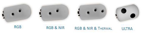
Multi-Camera POD
Deployed through a small aerial survey camera system, our solution allows the capture of high-quality drone imagery ensuring a viable solution to a broad spectrum of applications.
Sensor Specifications
Dual Camera Sensor Array
11,900 pixels x 4,000 pixels (XT AT)
3.7 µm pixel Size
59.1 degrees FOV40mm Calibrated Lenses
Triple Camera Sensor Array
RGB 5,184 pixels x 3,456 pixels (XT AT)
NIR 5,184 pixels x 3,456 pixels (XT AT)
FLIR 640 pixels x 512 pixels (XT AT)
29.5 degrees FOV
Dual Camera Sensor Array
RGB 5,184 pixels x 3,456 pixels (XT AT)
NIR 5,184 pixels x 3,456 pixels (XT AT)
29.5 degrees FOV
4.4 µm pixel size
40mm Calibrated Lenses
Dual Camera Sensor Array
17,100 pixels x 5,792 pixels (XT AT)
4.14 µm pixel size
50mm or 85mm calibrated lens option
78.0 degrees FOV (50mm lens)
46.0 degrees FOV (85mm lens)
GET IN TOUCH...
To arrange a consultation or workshop, send us a message.